Locating Shipwrecks
- Mar 17, 2018
- 4 min read
Updated: Jan 12

Side scan sonar is probably the most effective tool for finding unburied targets. Black Laser Learning’s® Founder Vince Capone has located hundreds of shipwrecks, aircraft, anchors, and other objects lost at sea using all types of technology. Its detection and discrimination qualities allow for excellent capabilities to locate and identify targets. Additionally, side scan has excellent range, thus making it a cost-effective option with the ability to cover large areas quickly.
Large steel shipwrecks usually present larger and stronger reflecting targets. However, one must always consider the unknown. Working with Garry Kozak, Mike Fletcher, and several of the “Sea Hunters”, we searched for the 441-foot-long liberty ship Alexander Macomb. Constructed of steel with a beam of over 50 feet, she displaced almost 15,000 tons. We expected this humongous target to stand out like Hatteras Light on a clear summer’s night. After several hours of searching near the reported sinking, we did locate a target but she was not nearly as intact as we had expected her to be.

In the early 1960s, a salvage company from England had located the ship and salvaged her cargo. Sherman tanks and P-38 aircraft were among the materials listed on the manifest but these were cast aside like pieces of unwanted scrap. The salvors removed over 1,700 tons of copper and aluminum from her holds. To cost-effectively get at the cargo, the salvage team used explosives to cut open her hull, so when the side scan sonar image of the Macomb appeared, it was nothing as we expected.
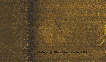
As archaeologists and divers, we are often interested in older shipwrecks with hulls made of timber instead of iron or steel. While a sailing ship found in the Baltic sea or Great Lakes may still have masts standing, timber vessels lost at sea are usually a far cry from their former selves. Look carefully at the 500 kHz, 100m range image on the lower left side of this article. See anything of interest?
If you were looking for a shipwreck from the 1700s or 1800s on the Mid-Atlantic coast of the United States, this may be the only clue above the sediment that here lies the wooden bones of an old sailing vessel. While the web image lacks the resolution for true analysis, a close examination of the original sonar image clearly shows a long, straight structure above the sand. Faintly visible, a parallel and mirror image approximately 8 meters away makes this target more interesting. Subtle, yes, but attention-grabbing. We can image the remains of two sides of a wood hull with all the superstructure gone. However, what sets this image apart from a possible debris field versus a shipwreck? In between the two possible hulls are a few very faint but visible targets, which could be cargo or more remains of the vessel’s structure.

To properly analyze a side scan image, you need to be able to adjust the gains in the zoomed target window. Software such a Chesapeake Technologies Sonar Wiz or Klein Sonar Pro do just that. The above target analysis was not made based solely on the image you see. We adjusted gains, magnified the image and changed contrasts to derive the best information. One target view is never enough. Every sonar pass exhibits subtle differences which lead to clues of the true nature of a target. The standard operating procedure here is to make additional passes, shortening the range to increase resolution.
The only downside to side scan is the inability to see beneath the sediment. Older shipwrecks or targets in dispositional areas may be covered with sediment. Typical side scan systems will miss these objects. To effectively search for potentially buried targets, we often combine the side scan sonar with a magnetometer. The magnetometer allows us to detect buried ferrous objects that the side scan alone would miss. Unfortunately, the range of the magnetometer is less than that of a sonar and we must adjust survey lane spacing accordingly.

A typical question once a wreck is found is, “Is this my target?” So, how do you know you have the wreck you’re looking for? Much depends on the data available, both historical and from the survey. Historically, you must ask what makes your objective unique. In searching for the U-215, we knew we had the correct submarine because she was a mine layer and thus slightly longer than other possibilities. Suppose you’re looking for a paddle-wheeler. There may be remnants of the paddle wheels evident in the sonar image. Maybe not. If you find remains of masts, you need to know how many are on your target and how many there should be. Most sailing vessels from the 1700s and 1800s have very few characteristics, such as the vessel pictured here. From this image, we can discern an approximate length and beam, but how do we determine its true identity?
A skilled remote sensing expert will use all the clues available. Notice the debris field just off the wreck? Maybe something specific to the cargo can be matched to the debris. Possibly the magnetic anomaly is weaker or stronger than would be expected for a shipwreck of that era. In the end, lacking strong clues, as is usually the case on an older shipwreck, only physical evidence from the wreck can ultimately determine her identity.


Comments